FunKidsActivities

Sierra Azul Open Space Preserve

Mt Umunhum Rd, San Jose, CA 95120, USA

Overview

Category:Hiking with Kids
Location:San Jose, CA

Expert Summary

Detailed Insights

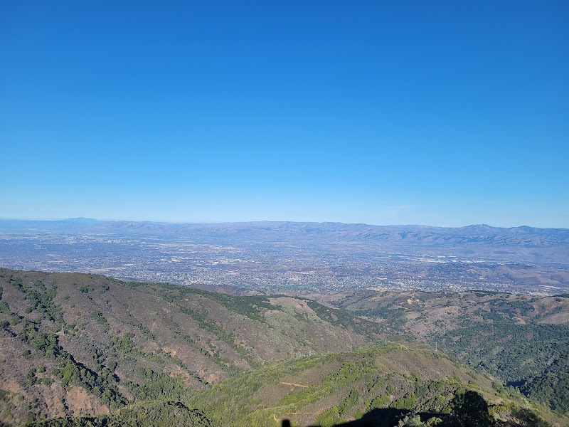
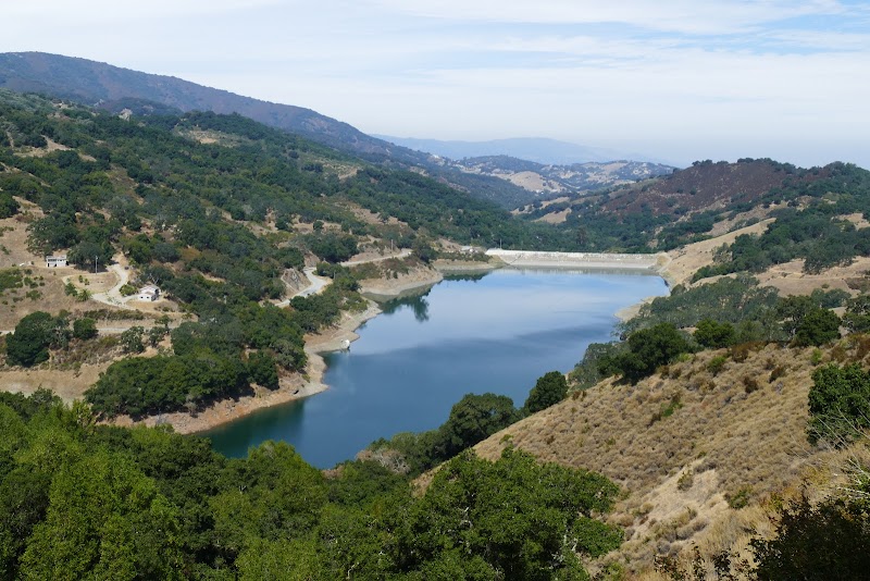
Sierra Azul Open Space Preserve provides an accessible, high-elevation outdoor experience centered around Mount Umunhum. It's a prime destination for families seeking spectacular panoramic views across the San Jose area, Silicon Valley, Santa Cruz, and even the ocean, often with a unique historical element at the abandoned radar station. The preserve offers a range of activities from easy scenic drives to challenging hikes and biking, with newly renovated facilities and shaded trails for comfort.

Key Highlights

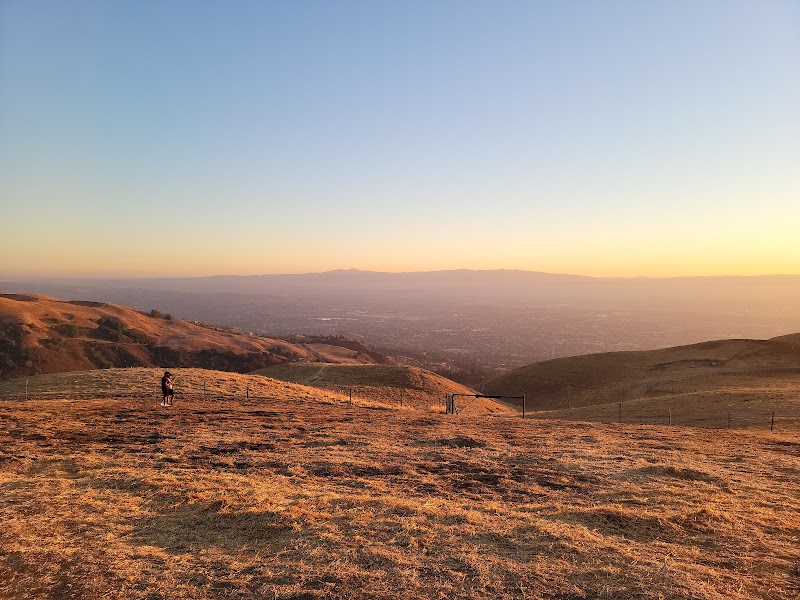
  • Spectacular panoramic views from Mount Umunhum Summit, visible from a large parking lot or short walks.
  • Drive-up access to the summit, making it accessible for families with young children, strollers, or less mobile members (e.g., aging parents).
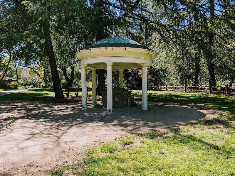
  • Historic abandoned radar station (exterior viewing only) with an informative pavilion about its history, reached by a short flight of stairs from the summit parking.
  • Trails with ample shade, providing comfort during summer visits.
  • Newly opened/renovated roads, parking, trails, and picnic areas, indicating good maintenance and modern amenities.
  • Trails suitable for biking, offering an alternative activity for active families.

Standout Features

  • The convenience of driving directly to the Mount Umunhum Summit for immediate breathtaking views.
  • Large, newly renovated parking lot at the summit, which itself is a prime viewing spot.
  • The educational aspect of the abandoned radar station and its historical pavilion.
  • Dedicated picnic areas with phenomenal panoramic views.
  • Trails that accommodate both hiking and mountain biking.

Perfect For

All Ages (Infants to Seniors): Ideal for scenic drives to the summit. The large parking lot at the summit provides immediate access to stunning views and a short, stair-accessed walk to the historical radar station, suitable for all mobility levels.
Active Kids (6+ years) & Teens: Excellent for longer hiking adventures (e.g., 8-mile hike to the peak, 3+ mile downhill trails) due to steady but not steep elevation and shaded paths. Also suitable for biking on designated trails.
Younger Children (Toddlers-5 years): Can enjoy the views and the radar station area. Shady, wider sections of trails might be suitable for short walks, but parents should be aware that other sections can be narrow and uneven.

Ideal For

Families seeking a scenic drive and easily accessible panoramic views with minimal walking.
Multi-generational family outings, accommodating individuals with varying mobility levels.
Active families who enjoy moderate hiking or mountain biking on shaded trails.
Parents looking for an outdoor activity that combines natural beauty with a historical learning opportunity.
A relaxing picnic outing with spectacular backdrops.

💡Pro Tips from Reviews

  • Bring a light jacket, as it's often breezy at the peak, even on warm days.
  • Check your vehicle's tire condition before visiting due to reports of a rough road.
  • Pack hand sanitizer, as hand washing is not available in the summit bathroom.
  • Download any necessary maps or information beforehand due to extremely poor cell signal.
  • Allocate sufficient time for longer trails (e.g., 3+ miles), ensuring you can return safely before 5 PM (implied closing/darkness).
  • Bring your own lunch and snacks to utilize the picnic areas while enjoying the expansive views.
  • Consider a winter visit for a chance to see light snow at the peak, adding a unique experience.

Things to Consider

  • The road to the summit can be rough; parents should ensure their vehicle's tires are capable.
  • Cell signal is extremely weak and intermittent at the summit and mostly absent on trails, making communication or online navigation difficult.
  • The bathroom at the top of the mountain does not have hand washing facilities.
  • Dogs are strictly prohibited on all trails.
  • The radar station itself cannot be entered or explored inside.
  • Some trails are described as narrow and go up and down, which may be challenging for very young children or specific strollers.

Price & Value

No entrance fees or parking costs were mentioned in the reviews, suggesting Sierra Azul Open Space Preserve is free to access. The value proposition is high, offering extensive natural beauty, well-maintained facilities (new roads, parking, trails, picnic areas), and varied recreational activities without a direct cost.

Accessibility & Special Needs

  • Direct vehicle access to the Mount Umunhum Summit is available, which is highly beneficial for aging parents, individuals with mobility issues, or families with strollers/young children.
  • A short flight of stairs leads from the hilltop parking lot to the abandoned radar station.
  • Trail conditions vary; some sections are wide and likely stroller-friendly, while others are described as narrow and up/down.

🍎Food & Drink Policy

  • Outside food is encouraged, with picnic areas explicitly mentioned and recommended for enjoying meals with the views.
  • No explicit restrictions on bringing personal food or drinks were stated.

🚗Parking Info

  • A large, newly renovated parking lot is available at the Mount Umunhum Summit Area, offering convenient access and excellent views.
  • A smaller parking lot is also available halfway up the mountain.
  • Parking appears to be ample and well-maintained.

👥Crowd Levels

  • Reviews do not explicitly mention crowd levels, but the presence of large, newly renovated parking and facilities suggests it can accommodate a significant number of visitors. No reports of excessive crowding or difficulty finding space were made.

🛡️Safety Features

  • Improved facilities and trail upkeep contribute to overall visitor safety and experience.
  • A review implicitly advises planning time to 'get home safely before 5 o'clock' for longer trails, suggesting awareness of potential hazards like darkness or park closing times (though no specific safety personnel or explicit safety features like first aid stations were mentioned).

When to Avoid

  • Families who rely on constant cell phone connectivity for navigation, communication, or emergencies.
  • Parents planning to bring their dog, as pets are not permitted on the trails.
  • Visitors expecting to tour the interior of the radar station.
  • Families with very young children planning extensive trail use without prior knowledge of specific trail conditions (some are narrow and up/down).

Pricing/Package/Events

Events & Schedule

Special Events(Last 2 months - Next 6 months)

Scenic Aerobic Hike

Wednesday, October 8, 2025

Free (implied by 'Free Docent-Guided Activities' across Midpen preserves)

Habitat Restoration: French Broom Removal

Thursday, October 9, 2025

Free (implied)

Trail Maintenance: Mt. Umunhum Trail (Pt. 3)

Thursday, October 9, 2025

Free (implied)

Wonders of Cherry Springs

Sunday, October 12, 2025

Free (implied)

Sentinel in the Sky

Sunday, October 19, 2025

Free (implied)

Oak Academy

Friday, November 7, 2025

Free (implied)

🍎Food Policy

  • Pack out all trash (leave no trace), no trash cans available.
  • Littering is prohibited.
  • Do not feed wild animals.
  • Dispose of organic waste (e.g., fruit peels/pits) properly to prevent attracting animals.

🛡️Safety Policy

  • Use designated trails to avoid damage to natural resources and prevent injury.
  • Avoid blocking the trail; step aside to allow others to pass.
  • Yield to equestrians when walking or biking.
  • Do not leave valuables in vehicles; lock vehicle and store items out of sight or take them on the trail.
  • Travel in groups of two or more for assistance in case of accident or emergency.
  • Dress in layers appropriate for temperature changes, time of year, and planned activities.
  • Carry water (2 quarts per person for a 2-hour hike recommended, as drinking water is not available at most preserves).
  • Apply sunscreen and drink plenty of water prior to and during outdoor activities.
  • Be aware that cell service is very sporadic on the preserves.
  • Be prepared for naturally occurring hazards: Rattlesnakes (active in warm weather), Poison oak (learn to identify and avoid in all seasons), Ticks (may carry diseases), Mountain lions (occasionally seen, maintain distance, do not approach or feed).
  • Leave plants and animals undisturbed (take photos, do not pick flowers).
  • All wildlife and their surrounding habitat are protected; do not approach, touch, startle, or feed wildlife.
  • Swimming, wading, or engaging in any water-contact activity in any District water areas is prohibited.
  • Fires are prohibited.
  • Smoking is prohibited.
  • Weapons of any kind are prohibited.
  • Drones, model airplanes, and model rockets are NOT allowed.
  • Bicyclists must wear helmets at all times and observe a 15-mph trail speed limit (5-mph when passing or approaching blind turns).
  • Equestrians are recommended to wear helmets.
  • In case of emergency (fire, accident, immediate threat to life/property), call 911. For non-emergencies, call Midpen main office at 650-691-1200 (or 650-968-4411 on weekends/after 5 PM for unusual wildlife encounters).

📅Booking Policy

  • A general access permit is required for any activity or event that: may be attended by twenty (20) or more people; OR would restrict the use of any part of Midpen lands by members of the public; OR requests or requires a fee be paid or a donation made for participation (including mandatory purchases).
  • A large group/event permit is required for any event attended by 50 or more people or more than three equestrians.
  • Permit applications should allow a minimum of 2 working days for processing.
  • Most permits are free of charge, and applications are available online.
  • Group activities are not allowed at Mount Umunhum on weekend days and holidays (permits are not available for these times).

🚗Parking Information

  • Kennedy Roadside Parking (3 spaces): Located in Los Gatos on Kennedy Road at gate #SA01.
  • Mount Umunhum Summit Parking Area (54 spaces + 3 ADA): Located at the top of Mt. Umunhum road, approximately 5.3 miles past the intersection with Hicks Road. Stairs lead visitors to the Summit. A limited number of accessible parking spaces (3 ADA) are located 0.2 miles further up Mt. Umunhum Road within the passenger dropoff/turnaround area.
  • Jacques Ridge Parking Area (11 spaces + 1 ADA): For Woods Trail trailhead. Located near the intersection of Hicks Road and Mt. Umunhum Road.
  • Jacques Ridge Equestrian Parking Area (7 equestrian spaces): Located on Almaden Quicksilver County Park lands, at the edge of Sierra Azul preserve.
  • Bald Mountain Parking Area (23 spaces + 1 ADA): For Mt. Umunhum Trail and Bald Mountain Trail trailheads. Located on Mt. Umunhum Road, approximately 1.7 miles past the intersection of Hicks Road.
  • Bald Mountain Roadside Parking (4 spaces).
  • Miller Point Parking Area (33 spaces + 2 ADA): Located in Lexington Reservoir County Park land, south of the County's Banjo Point Parking Area and gate SA21 which leads into Priest Rock Trail.
  • Parking is free.
  • Parking spaces may not be available during peak visitation or on holiday weekends.
  • Visitors must only park in authorized spots.
Information extracted from official website • Last updated: Sep 29, 2025

What People Say

What's Great

  • Spacious play areas (mentioned in 6 reviews)

Areas for Improvement

  • Parking can be challenging (mentioned in 4 reviews)

Recent Reviews

Zsuzsanna Sziveri

Zsuzsanna Sziveri

3 months ago

Did an 8 mi hike to the peak. Easy trails with steady, but not steep elevation. Nice views of the San Jose area.

Angel Hou

Angel Hou

a year ago

Sierra Azul Open Space Preserve Standing on the top of the mountain and looking down below, you feel like you can see all at a glance. Excellent opportunity for exercise PARKING LOT: The parking lot at the top of Sierra Azul Parking Lot At Mount Umunhum Summit Area is quite large and is also one of the best places for viewing. In addition, there is a small parking lot before reaching the top of the mountain. If you want to see the abandoned radar station, you still need to walk a long way. Sceneries 1. The most outstanding thing is this abandoned radar station. You cannot visit the inside of the building, only the outside. But there is a pavilion next to the building to learn about the history of the radar station, and it is also one of the viewing spots. The radar station is reached by climbing a short flight of stairs from the hilltop parking lot. 2. There is a trail next to the radar station, which can lead to the parking lot.This journey is very short and sunny, and the road is narrow. The intersection heading down the mountain can also lead to a small parking lot halfway up the mountain. This section is basically shady throughout. The first half of the road is relatively wide, and the second half of the road becomes relatively narrow up and down. bathroom Located in the parking lot at the top of the mountain, hand washing is not allowed. Signal The signal at the top of the mountain is extremely weak and intermittent. There is basically no signal on the trail. There will be a signal occasionally but it is extremely unstable. other You can ride bikes on the trail, but you cannot walk dogs. If you want to go down the trail, it must be at least more than 3 miles. Calculate your time in advance and get home safely before 5 o'clock.

Cheryl Trapp

Cheryl Trapp

a month ago

Stunning views. It's usually breezy up their bring a light jacket. Road is a rough one so make sure your tires can handle the road. Worth a trip up to see the old communication station. A piece of history!!

Sonal Ranjan

Sonal Ranjan

4 years ago

Trails around Mt Umunhum have been a great pleasure. The views from the top are wonderful. One can drive all they way up to the top - a real blessing for our aging parents. The peak gets a smattering of snow in the winter. The trails have ample shade - which is helpful in the summer time. Facilities and trail upkeep have been getting better.

Michael Sharpe

Michael Sharpe

7 years ago

An absolutely stunning location. Just opened, new roads, parking, trails, picnic area. The views are phenomenal. I highly recommend going. Bring lunch and smooth the views from the Ocean, Santa Cruz, to Silicon Valley and My. Hamilton!

Contact Information

Mt Umunhum Rd, San Jose, CA 95120, USA

View on Google Maps

Quick Stats

Overall Rating
4.7
Total Reviews706
Recent Reviews5